Atmospheric Physics, Meteorology and Safety (2)
Physics of the Atmosphere, Meteorology, and Safety (1)
The physics of the atmosphere is primarily described by meteorology, which is the science of Earth’s atmosphere, its composition, properties, phenomena, and processes occurring within it. It mainly utilizes physical knowledge and solution methods, referred to as the physics of the atmosphere.
Sources Used:
Klima skripta. Gisáci na UPOL: GIS GEOINFORMATIKA A ROMANTIKA [online]. Olomouc: MarijaStudio, 2007 [cit. 2017-09-03]. Dostupné z: http://www.gisaci.upol.cz/filesftp/Klima_skripta.pdf
NEČAS, Tomáš. Fyzika v atmosféře aneb základy meteorologie: Modulární systém dalšího vzdělávání pedagogických pracovníků JmK v přírodních vědách a informatice CZ.1.07/1.3.10/02.0024. Brno: Přírodovědecká fakulta, Masarykova univerzita v Brně, 2011.
SKŘEHOT, Petr. Atmosférické optické jevy. Meteorologická Optická Rada. [Online 3. 9. 2017]. Dostupné z: www.astronomie.cz/download/atmosfericke-opticke-jevy.pdf
Air flow as a physical phenomenon
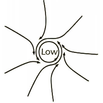
One of the basic features of the Earth’s atmosphere is the constant movement and displacement of varying volumes of air. The atmosphere tends to equalize these differences, and the manifestation of this is the airflow. The orientation of the direction of flow always moves from an area of higher air pressure to an area of lower air pressure. It involves the transfer of mass particles as well as thermal energy. Under the term “flow,” we understand a disordered movement, although in the atmosphere, we can also encounter organized flow.
Climate script. Gisáci at UPOL: GIS GEOINFORMATICS AND ROMANTICISM [online]. Olomouc: MarijaStudio, 2007 [cit. 2017-09-03]. Available at: http://www.gisaci.upol.cz/filesftp/Klima_skripta.pdf:
Laminar flow – a form of flow without turbulent vortex movements, created above an aerodynamically smooth surface. Air particles move parallel to the direction of flow. It only occurs in a thin layer above the so-called aerodynamically smooth surface. It is extremely rare and does not occur when flowing over an aerodynamically rough surface (vegetation, built-up areas, etc.).
Katabatic flow – a descending, gliding movement of cold air, e.g. along an inclined geographical relief.
Anabatic flow – an upward gliding flow along an inclined geographical relief. Anabatic character also applies to the upward flow of warm air on anafronts.
Convection – upward flow caused by horizontal inhomogeneity of the atmosphere. A necessary condition for its development is the overheating of the active surface, associated with an increase in barometric pressure. If convection takes place in a closed ring, it is called a convection cell. This characterizes organized convection. Thermal convection (thermal turbulence used in sport aviation) and forced (mechanical) convection are distinguished – aided by the initial impulse of airflow from orographic obstacles.
Subsidence – slow descending, settling movements inside an air mass. It causes adiabatic warming of the air and dissolves the formed clouds.
Turbulence – the most common, characterized by irregular and disordered vortex movements. Also, vertical height variation and roughness of geographical relief. It develops from laminar flow when the critical speed is exceeded. The degree of turbulence is determined by the character of the thermal stratification of the atmosphere. Turbulence is associated with gustiness of the wind in the atmosphere and contributes to air mixing and the transfer of heat, water vapor, and air pollutants.
Vortices – created mechanically (roughness of relief) = orographic turbulence or a result of instability in the temperature stratification of the atmosphere – thermal = convective or storm turbulence.
Advection – transfer of a certain volume of air through atmospheric flow.
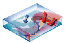
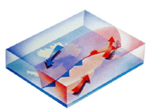
Causes of movement – the causes that induce movement are the force of the horizontal pressure gradient, Coriolis force (earth’s rotation, deflection of masses to the right in the Northern Hemisphere and to the left in the Southern Hemisphere – see figure 39), frictional force (against the direction of movement). “Wind, which contains a predominant horizontal component of air movement, can be expressed by a vector and is characterized by direction and speed” – formula see source2.
Climate script. Gisáci at UPOL: GIS GEOINFORMATICS AND ROMANTICISM [online]. Olomouc: MarijaStudio, 2007 [cit. 2017-09-03]. Available at: http://www.gisaci.upol.cz/filesftp/Klima_skri.
Geostrophic wind – the simplest air movement, ideal horizontal, uniform, straight-line flow without friction. If we stand with our backs to the wind, TN is in front on the left, TV is behind on the right.
Cyclones – phases – front, wave, young cyclone, occlusion, dying cyclone.
Wind speed – measured in m.s -1 , max. Mt. Washington 416 km/h. Winds with speeds greater than 5 m/s are gusty..
Wind direction – a northern wind comes from the north. If the change exceeds 45°, it is a variable wind..
Beaufort scale 13 degrees:
0 – calm, 1 km/h,
1 – breeze,
2 to 8 – light wind to stormy,
9 to 11 – gale,
12 – hurricane > 118 km/h.
Daily wind speed pattern – maximum is around 14:00, minimum is at night or in the morning. Direction for the northern hemisphere – increasing speed in the morning and veering to the right, decreasing after noon and veering to the left..
Atmospheric circulation systems
The circulation of the atmosphere is always accompanied by the transfer of energy, momentum, and water. Basic types include: Jet stream, air circulation in cyclonic and anticyclonic systems, trade wind and monsoon circulation. Mesoscale circulations – hurricanes, tornadoes, breezes, mountain and valley winds.
Climate script. Gisáci at UPOL: GIS GEOINFORMATICS AND ROMANTICS [online]. Olomouc: MarijaStudio, 2007 [accessed 2017-09-03]. Available from: http://www.gisaci.upol.cz/filesftp/Klima_skripta.pdf
The circulation is influenced by:
- Solar radiant energy – the uneven distribution of radiant energy is one of the main triggers for circulation.
- Earth’s rotational movement – due to the formation of the Coriolis force, at the equator = 0, at the poles the most.
- Surface heterogeneity – affects the temperature of the air, and due to turbulent mixing, it is present throughout the troposphere.
- Friction between air and the earth’s surface – causes a reduction in speed and a change in direction, only up to an altitude of about 1.5 km.
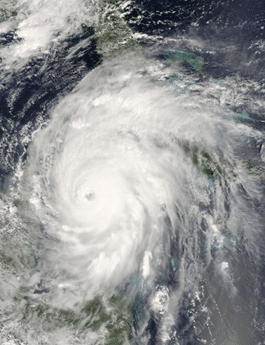
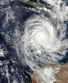
If the Earth were not rotating and had the same surface, it would be ideal – warm air from the equator moving to the poles – cooling, and back to the equator. Around the equator, a tropical calm zone forms = tropical convergence zone = NT, trade winds in the northern hemisphere from the northeast, in the southern hemisphere from the southeast. Tropical cyclones are disturbances in the atmosphere in low latitudes. They differ from extratropical ones by their smaller size, low pressure at the centers, and high speeds. Air vortices with a maximum diameter of several hundred km. Their movement follows the direction of the trade winds. They always form over the ocean and in the calm zone. The source is the surface water of tropical ocean areas with temperatures over 26°C. Tropical cyclones by location – hurricane or uragan – Central America, typhoon – Far East, cyclone – Bay of Bengal, Willy-Willies – between Australia and the Cocos Islands.
Climate script. Gisáci at UPOL: GIS GEOINFORMATICS AND ROMANTICS [online]. Olomouc: MarijaStudio, 2007 [accessed 2017-09-03]. Available from: http://www.gisaci.upol.cz/filesftp/Klima_skripta.pdf
3 basic types of atmospheric circulation:
- Zonal circulation – along parallels, for Western and Central Europe, warm and humid air from the Atlantic in winter and cool humid air in summer. It is crucial for the large water cycle.
- Meridional – along the meridians, cold C and warm A, allows the influx of cold air from the Arctic and warm air from the subtropics to Europe.
- Mixed – a combination of both.
Local circulatory winds with different characteristics: breeze winds, valley and mountain winds, glacier wind, foehn, bora, small-scale air vortices – whirlwind, trombes, tornadoes, urban wind.
Monsoons – uneven heating of the land and oceans.
El Niño – this phenomenon is the most well-known manifestation of disruption in the general atmospheric circulation. The translation means “Little Jesus,” as it regularly occurs during the Christmas period. It forms after a period of intensified trade winds, which leads to the displacement of a greater volume of ocean water westward. Thus, in the direction of the regular currents. After the weakening of the trade wind currents, the accumulated water flows back. It is marked by the disappearance of the cold Peruvian current along the western coast of South America. Off the coast of Peru, Ecuador, and Colombia, the water temperature rises (in 1983 by 11°C) and the water level increases by several centimeters. Consequences: Torrential rains, impact on fauna and flora, fish die due to the lack of food – affecting local fishermen. El Niño is also accompanied by pressure changes – ENSO – El Niño Southern Oscillations. A change in the general atmospheric circulation. It is proven that this anomaly also influences other phenomena – droughts in equatorial Africa, flooding in the Mississippi River basin… (generally endangering the life of birds, coral reefs, forest fires, marine life, coastal erosion, droughts, floods, and tropical storms).
Climate script. Gisáci at UPOL: GIS GEOINFORMATICS AND ROMANTICS [online]. Olomouc: MarijaStudio, 2007 [accessed 2017-09-03]. Available from: http://www.gisaci.upol.cz/filesftp/Klima_skripta.pdf
La Niña – an air current system, intensified trade winds enhance the upwelling of cold ocean water, intensifying cold ocean currents. > transfer of cold water from the eastern part of the Pacific Ocean to the west, a more significant rise in surface temperature in the western Pacific Ocean. It’s like the opposite of El Niño.
Climate script. Gisáci at UPOL: GIS GEOINFORMATICS AND ROMANTICS [online]. Olomouc: MarijaStudio, 2007 [accessed 2017-09-03]. Available from: http://www.gisaci.upol.cz/filesftp/Klima_skripta.pdf
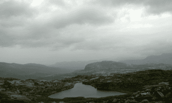
Formation of clouds and precipitation, optical phenomena
When water vapor condenses in the atmosphere, microscopic condensation nuclei form water droplets. These microscopic droplets cluster together to create larger cloud droplets and ice crystals. As they accumulate, clouds form. The water droplets remain at a certain height due to updrafts in the atmosphere. At temperatures up to -4°C, clouds form with water droplets only, while at temperatures below -12°C, the ice nucleus level is reached, and only ice nuclei are present. The water content of clouds indicates the amount of water they contain. 1 m³ = 0.2-5.0 g.
Climate script. Gisáci at UPOL: GIS GEOINFORMATICS AND ROMANTICS [online]. Olomouc: MarijaStudio, 2007 [accessed 2017-09-03]. Available from: http://www.gisaci.upol.cz/filesftp/Klima_skripta.pdf
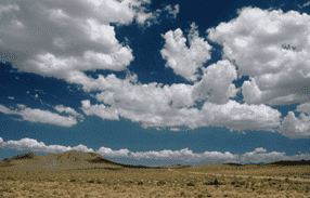
Clouds and their classification, optical phenomena
– water vapor condenses when the dew point is reached; this usually happens when humid air rises, causing its pressure and temperature to decrease.
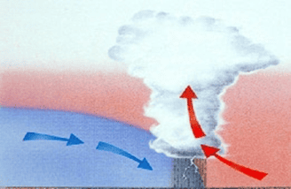
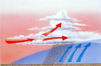
– what causes air to rise? (see picture)
• it is heated by the warm surface of the Earth (thermal convection),
• it hits an obstacle – mountains,

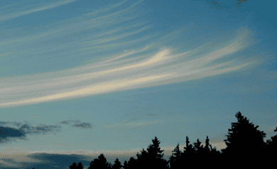
Cirrostratus (Cs) – thread layer, a translucent veil of clouds, fibrous or smooth in appearance, either fully or partially covering the sky – halo phenomena.
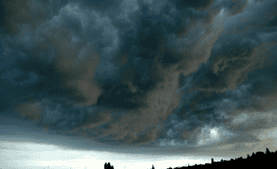
Nimbostratus (Ns) – rain layer, gray to dark cloud, dull appearance due to falling rain and snow precipitation, thick layer, the Sun does not pass through,
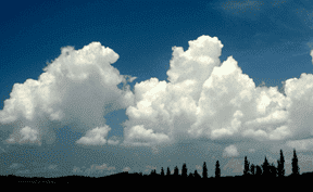
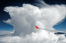
Cumulus (Cu) – heap, solitary clouds, dense with well-defined outlines, developing upward into towers and heaps, the top part cauliflower-shaped.
Climate script. Gisáci at UPOL: GIS GEOINFORMATICS AND ROMANTICISM [online]. Olomouc: MarijaStudio, 2007 [cited 2017-09-03]. Available at: http://www.gisaci.upol.cz/filesftp/Klima_skripta.pdf:
- High clouds – Ci, Cc, Cs – base h = 5-13 km, made of ice crystals, white and transparent.
- Middle clouds – As, Ac – h = 2-7 km
- Low clouds – Ns, St, Cu, Sc – gray and with precipitation, up to 2 km
- Clouds with vertical development – Cu, Cb – thunderclouds, hail.
- Convective clouds – formed within air masses or at fronts. In highly unstable air masses.
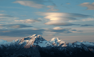
- Wave clouds – Sc, Ac
- Clouds from upward movements, clouds from radiation.
- Special: Pearly clouds (supercooled droplets), noctilucent clouds (cosmic dust), contrails (airplanes), clouds from fires, volcanic clouds.
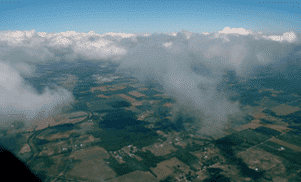
Cloudiness causes surface cooling – less radiation reaches the surface. Cloudiness significantly affects the climate. Synoptic meteorology – octaves, climatology tenths14
Climate script. Gisáci at UPOL: GIS GEOINFORMATICS AND ROMANTICISM [online]. Olomouc: MarijaStudio, 2007 [cited 2017-09-03]. Available at: http://www.gisaci.upol.cz/filesftp/Klima_skrip.
Optical phenomena in the atmosphere – photometeors according to:
- Halo phenomena – reflection and refraction of sunlight on ice crystals scattered in the air. These are bright, whitish, faintly rainbow-colored bands, arcs, or halos in the sky. A small halo (very common) and a large halo (less common) are distinguished, with the center always being the Sun. A very rare phenomenon is also the sundog – 1/year, as well as the halo column, circumzenithal arc, and anti-sun15.
Climate script. Gisáci at UPOL: GIS GEOINFORMATICS AND ROMANTICISM [online]. Olomouc: MarijaStudio, 2007 [cited 2017-09-03]. Available at: http://www.gisaci.upol.cz/filesftp/Klima_skr.
- Glory and corona – in thin water clouds, small circles (crowns) are observed in front of the sun and moon. The corona is caused by the bending of light on particles of clouds Ac, Cc, Cs. These circles are usually bluish to reddish. They are sometimes called aureoles16.
Climate script. Gisáci at UPOL: GIS GEOINFORMATICS AND ROMANTICISM [online]. Olomouc: MarijaStudio, 2007 [cited 2017-09-03]. Available at: http://www.gisaci.upol.cz/filesftp/Klima_skri.
- Colorful circles around the shadows of objects on clouds are called glory17.
Climate script. Gisáci at UPOL: GIS GEOINFORMATICS AND ROMANTICISM [online]. Olomouc: MarijaStudio, 2007 [cited 2017-09-03]. Available at: http://www.gisaci.upol.cz/filesftp/Klima_skripta.pdf.
- Rainbow – probably the most well-known optical phenomenon – refraction of light when a ray passes through air layers with a higher number of water droplets. The inner side is violet, the outer side is red18.
Climate script. Gisáci at UPOL: GIS GEOINFORMATICS AND ROMANTICISM [online]. Olomouc: MarijaStudio, 2007 [cited 2017-09-03]. Available at: http://www.gisaci.upol.cz/filesftp/Klima_skripta.pdf.
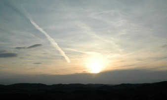
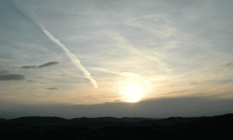
Dusk phenomena – after sunset or before sunrise, part of the sky is illuminated by scattered sunlight, unless it is completely covered by thick clouds. During this time, some optical phenomena can be observed, which arise from the combined effects of refraction, scattering, and absorption of sunlight in the atmosphere19.
NEČAS, Tomáš. Fyzika v atmosféře aneb základy meteorologie: Modulární systém dalšího vzdělávání pedagogických pracovníků JmK v přírodních vědách a informatice CZ.1.07/1.3.10/02.0024. Brno: Přírodovědecká fakulta, Masarykova univerzita v Brně, 2011:
- Purple glow, green flash, apparent enlargement of the sun or moon disk, others.
Optical phenomena in the atmosphere – others according to source20
SKŘEHOT, Petr. Atmospheric optical phenomena. Meteorological Optical Council. [Online 3. 9. 2017]. Available at: www.astronomie.cz/download/atmosfericke-opticke-jevy.pdf:
- Lightning – linear, branching, ball, or sheet lightning – lightning discharges that occur during thunderstorms, accompanied by thunder. Thunderstorms are classified by origin as frontal and local – arising from heat. Discharges of atmospheric electricity can occur within thunderclouds, between individual clouds, or between a cloud and the earth, which acts as a positively charged capacitor. In all three cases, a discharge occurs between differently charged regions in the form of a rapidly occurring lightning strike.
- Eliáš’s fire – during thunderstorms, charge may accumulate on the tips and raised metal objects, causing discharges of atmospheric electricity. Strong pointed discharges are also accompanied by sound effects (crackling) and sometimes clearly visible visual phenomena such as sparking and arcing.
- Aurora Borealis – these have either a ray-like or non-ray-like structure. In the first case, they are usually rapidly moving light phenomena in the form of colored rays, curtains, draperies, etc. The second type is observed as stationary or only slightly moving arcs, or just diffuse light. Aurora Borealis are most commonly observed in areas around the Earth’s magnetic poles, with the highest frequency occurring along a circle about 20–25° from these poles. The aurora forms through the interaction of electrically charged particles with molecules of highly diluted air, i.e. at altitudes from 80 to 1000 km above the Earth’s surface.
- Tyndall effect – based on the diffuse scattering of light passing through an optically heterogeneous system, manifesting as the visibility of the path of a light ray passing through a dispersion, observed perpendicular to its direction. The scattered light carries a bluish-white hue.
- Bishop’s Ring – a reddish-brown ring around the Sun, with an inner radius of about 10° and an outer radius of about 20°. As the Sun’s altitude decreases, both radii increase. It forms due to light bending on solid particles, usually of volcanic origin.
- Meteors – bright light streaks. They are caused by small bodies, usually in the micrometer to millimeter size range, orbiting the Sun at speeds of several kilometers per second. When such a body accidentally collides with Earth, it enters our atmosphere and heats up intensely as it moves through the air, exciting surrounding air particles to emit light. During its passage through the atmosphere, the body’s surface layers may melt, or even the entire body may melt due to friction with air molecules.
Atmospheric precipitation
Atmospheric precipitation refers to particles that form in the atmosphere by the condensation of water vapor and occur in the atmosphere, on the Earth’s surface, or on objects in liquid or solid form 21
Climate scripts. GISáci at UPOL: GIS GEOINFORMATICS AND ROMANTICISM [online]. Olomouc: MarijaStudio, 2007 [cited 2017-09-03]. Available at: http://www.gisaci.upol.cz/filesftp/Klima_skrip.
Vertical precipitation refers to precipitation that falls from clouds. The most well-known forms are rain and snow. Precipitation of a continuous nature most often falls from clouds of upward gliding Ns, As. Thunderclouds (Cb) typically bring only shower-type precipitation. In addition to continuous precipitation, we also observe drizzle, which is typical for warm and stable air masses and clouds St, Sc. Vertical precipitation according to the source 22
Climate scripts. GISáci at UPOL: GIS GEOINFORMATICS AND ROMANTICISM [online]. Olomouc: MarijaStudio, 2007 [cited 2017-09-03]. Available at: http://www.gisaci.upol.cz/filesftp/Klima_skripta.pdf.
- Rain – water precipitation in the form of drops, with a diameter from 0.5 to 7.0 mm. Rain is also considered when drops are smaller than 0.5 mm, but fall densely.
- Drizzle – small drops with a diameter of up to 0.5 mm, but they do not have sufficient intensity to be considered rain.
- Snow – solid precipitation consisting of ice crystals or their clusters of various shapes. The basic shape is a six-pointed plate – a snowflake. At higher temperatures, they form clumps, while at temperatures below -5°C, they form smaller flakes.
- Snow pellets – solid precipitation composed of white opaque ice particles, falling during showers around freezing point, with a diameter of 2-5 mm, which shatter upon impact.
- Snow grains – solid precipitation made of ice, smaller than snow pellets, smaller than 1 mm. They do not shatter upon impact and resemble drizzle at temperatures below freezing.
- Rime pellets – snow grains coated with a layer of ice, with a diameter of about 5 mm, at temperatures around freezing, accompanying rain, bouncing, and shattering.
- Freezing rain – falling transparent, semi-transparent ice grains with a diameter of 5 mm, formed by freezing raindrops, sometimes containing water inside.
- Hail – balls, pieces, or fragments of ice from 5-50 mm in size, weighing up to 0.5 kg.
- Ice needles – simple ice crystals in the form of needles, floating or falling very slowly. Typical for polar regions, but only occurring during severe frosts here.
Deposited (horizontal) precipitation – if the condensation process occurred on the Earth’s surface or on objects on it (buildings, trees, power lines, etc.):
- Dew – water deposition in the form of small droplets on the Earth’s surface, plants, or various objects. It forms due to radiational cooling when the temperature drops below the dew point. Most often observed in the evening or night during the warm season, with extremes ranging from 10-30 mm annually. In continental climates, it supplements the precipitation total.
- Frozen dew – frozen dew droplets.
- Hoarfrost – crystalline deposits similar to dew but always below freezing, with ice flakes and needles that have a fine structure, found on grass and horizontal surfaces, but not on trees or wires.
- Rime – fine needles, clumps with a distinct crystalline structure, deposited during severe frosts on trees and power lines.
- Wetting – water droplets on windward sides.
- Hoarfrost – white transparent granular deposit consisting of snow-white clumps on the windward side of objects. It forms during fog at temperatures from -2°C to -10°C on the ground, objects, trees, power lines, and aircraft in flight.
- Glaze – continuous transparent ice deposit, frozen droplets from rain or drizzle.
- Black ice and frost – freezing of droplets after they have fallen to the ground.
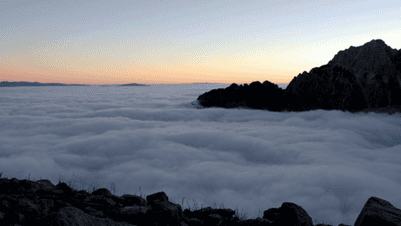
Inversion
Inversion – the term refers to an unusual vertical distribution of air temperature. In a certain “inversion” layer, the temperature of the air increases with altitude. It usually affects not very thick layers of the troposphere. They are characterized by the height (surface and upper layers), in which they occur, thickness (upper and lower limits of the inversion), temperature difference, and temperature gradient. If the inversion occurs in several layers stacked on top of each other – mixed inversion. According to the cause of formation, we divide inversions into: advective, frontal, radiational, subsidence, turbulent, and trade wind inversions 23
Climate scripts. GISáci at UPOL: GIS GEOINFORMATICS AND ROMANTICISM [online]. Olomouc: MarijaStudio, 2007 [cited 2017-09-03]. Available at: http://www.gisaci.upol.cz/filesftp/Klima_skripta.pdf