Atmospheric Physics, Meteorology and Safety
Atmospheric physics is primarily described by meteorology, i.e., the science of the Earth’s atmosphere, its composition, properties, phenomena, and processes occurring in it. It mainly utilizes physical knowledge and methods of solving, referred to as atmospheric physics. According to the source, the field of meteorology is divided by focus into:
- dynamical – formulates and mathematically solves relationships and equations describing the statics, dynamics, and thermodynamics of the atmosphere, with the goal of providing an objective, physically supported weather forecast,
- synoptic – analyzes and studies atmospheric phenomena on a larger scale; analysis and weather forecasting,
- physical – physics of clouds and precipitation, the study of radiation in the atmosphere, optical, electrical, and acoustic phenomena in the atmosphere; applies methods of experimental physics,
- satellite – obtaining and processing data from outer space,
- radar – using radio waves in the atmosphere to locate and assess meteorological targets.
For the purposes of safety fields, physical meteorology is particularly interesting, along with some areas of applied meteorology, i.e., besides biometeorology and agrometeorology, primarily aviation and maritime meteorology.
Atmospheric physics is also related to climatology, i.e., the study of climates: the science of the Earth’s climates, the conditions and causes of their formation, the science of the influence of climate on humans, objects of human activity, and vice versa.
From the perspective of physical meteorology, we will focus on the following areas and questions: thermal phenomena in the atmosphere and air circulation, water in the atmosphere, atmospheric pressure, cloud and precipitation formation.
Sources used:
- Climate scripts. GISáci at UPOL: GIS GEOINFORMATICS AND ROMANTICISM [online]. Olomouc: MarijaStudio, 2007 [cited 2017-09-03]. Available at: http://www.gisaci.upol.cz/filesftp/Klima_skripta.pdf
- NEČAS, Tomáš. Physics in the atmosphere or the basics of meteorology: Modular system for further education of educational staff JmK in natural sciences and informatics CZ.1.07/1.3.10/02.0024. Brno: Faculty of Science, Masaryk University, Brno, 2011.
Complete climate system (UKS)
The atmosphere is part of the Complete Climate System, which consists of 5 elements: Atmosphere; Hydrosphere; Cryosphere; Biosphere; Earth’s surface. Where all elements, except for the atmosphere, make up the so-called active surface, i.e., the part of the landscape sphere where radiation is reflected, and where the transformation of short-wave solar radiation into thermal energy occurs.
The immediate state of the complete climate system is called weather. The statistical collection of all states through which the complete climate system passes over several decades is called climate.
Meteorological measurements
For the collection and processing of meteorological data, meteorological stations and observatories are used. The main activity of the stations is the measurement and observation of meteorological and other phenomena. According to the source1
Climate script. Gisáci at UPOL: GIS GEOINFORMATICS AND ROMANTICISM [online]. Olomouc: MarijaStudio, 2007 [cit. 2017-09-03]. Available from: http://www.gisaci.upol.cz/filesftp/Klima_skripta.pdf
:
- Measured elements – temperature, humidity, air pressure, wind direction and speed, precipitation, snow cover height, duration of sunshine, ground minimum temperature at 5 cm, photon dose equivalent incident.
- Observed elements – horizontal visibility, cloud cover, cloud characteristics (amount, type, height of the base), weather conditions and trends, dangerous and special atmospheric phenomena and sudden weather changes .
- Additional activities – water evaporation from the water surface, soil temperature at depths of 5,10,20,50,100 cm, solar radiation monitoring, air quality monitoring (SO2, NOx, particulate matter, ground-level ozone), photographing bolides (very bright meteor) for the AVČR.
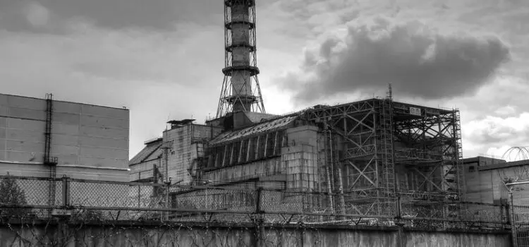
- The Dukovany and Temelín observatories, in addition to regular tasks, also provide meteorological support for nuclear power plant operations.
Remote measurements and observations are an indispensable supplement to ground-based ones in meteorology. These include radar, aerological, and satellite measurements and observations, according to the source2
Climate script. Gisáci at UPOL: GIS GEOINFORMATICS AND ROMANTICISM [online]. Olomouc: MarijaStudio, 2007 [cit. 2017-09-03]. Available from: http://www.gisaci.upol.cz/filesftp/Klima_skripta.pdf
- Radar measurements (digital and analog) – determining the distribution of instantaneous intensities of atmospheric precipitation;
- Aerological measurements (balloons, aircraft, radiosondes, ozonographic probes, indirect aerology from the Earth’s surface) – measurements primarily of the upper layers of the atmosphere – temperature, air pressure, humidity, wind direction and speed, ozone research in the atmosphere, monitoring radioactivity and measuring some long-wave radiation components;
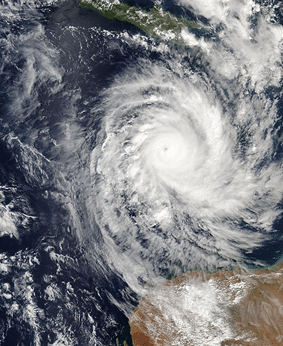
- Satellite measurements (automatic or artificial, manned, orbital space stations) – synoptic measurements, weather forecasting, cloud study, wind speed estimation, tropical cyclone research, hurricane and typhoon prediction; satellite climatology also deals with anomalies in the geophysical field, anomalies in long-wave radiation flux, creating climate zones, global maps.
Surface temperatures, maps of average monthly temperatures between day and night, maps of average monthly water vapor values in the atmosphere.
Earth's atmosphere
The atmosphere is the gaseous envelope of the Earth, i.e., a mixture of gases that do not interact with each other, known as air. The Earth’s atmosphere was formed by the outgassing of lava, which created the Earth’s crust. Lava under certain conditions contains 7-8% water vapor, which was released into the atmosphere when the lava flowed to the surface. Volcanic gases also contain CO2, SO2, Cl2, CH4, NH3, H2S, H2, etc.
Atmospheric Aerosols – aerosols – dispersion of solid or liquid particles ranging in size from 10-6 to 10-2 μm in gases. All liquid and solid particles in the atmosphere are aerosols. They act as condensation or crystallization nuclei. About 10% of aerosols have an anthropogenic origin, the rest are natural. Small aerosols reflect about 90% of solar radiation, thus causing the cooling of the Earth’s surface.
The atmosphere is classified according to various properties: thermodynamic, chemical, or kinematic processes, chemical composition.
Vertical distribution of the atmosphere according to temperatures
Troposphere – the lower part of the Earth’s atmosphere, directly adjacent to the Earth’s surface; the troposphere is influenced by the Earth’s surface; it constitutes up to 75% of the atmosphere’s mass; the tropopause separates it from the higher layer, below which is the so-called jet stream area – up to 300 km/h (important for aviation safety); the layer of the troposphere directly adjacent to the Earth’s surface is the boundary layer; further subdivided into three more layers – laminar (over aerodynamically smooth objects such as water surfaces, snow cover), near-surface intermediate layer, and the (Prandtl) Ekman spiral layer – turbulent movement,
Stratosphere – up to 55 km in height, in the lower part (20-25 km), nearly isothermal, from 25 km, the temperature increases due to the absorption of UV radiation; the maximum temperature is about 0°C; water vapor in the stratosphere forms nacreous clouds; ends with the stratopause,
Mesosphere – 50-85 km upper boundary, temperature from 0° to –90° (summer) and –50°C (winter), silvery clouds (cosmic and volcanic dust and ice crystals), mesopause, thermosphere,
Thermosphere – from 80-90 to 450 km, rapid temperature increase, 200 km = 500°C, 600 km = 1500°C, the aurora borealis also occurs here – the trapping of solar corpuscular radiation into the Earth’s magnetic field.
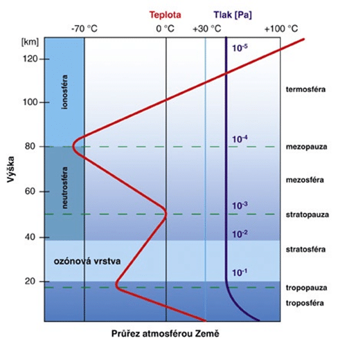
Vertical distribution of the atmosphere according to other properties
Vertical division according to physicochemical processes according to the source4 Climate Scripts. GIS Students at UPOL: GIS GEOINFORMATICS AND ROMANTICISM [online]. Olomouc: MarijaStudio, 2007 [cit. 2017-09-03]. Available at: http://www.gisaci.upol.cz/filesftp/Klima_skrip:
Neutrosphere – up to 60-70 km, the concentration of ions is so low that radio waves do not reflect on them, primarily uncharged particles,
Ionosphere – from 60 to 500 km, gases are highly conductive due to the high concentration of ions, sometimes affecting radio communication,
Chemosphere – photochemical reactions of O2, O3, N2 molecules occur here,
Vertical division according to the nature of kinetic processes:
Exosphere – outer atmosphere, 500 – 700 km, low air density and high kinetic energy, particles here can leave the atmosphere (dispersion sphere). Around the Earth are also 2 radiation belts – radiation belts.
Vertical division according to chemical composition:
Homosphere – up to 90 km, the volumetric proportion of gases in the mixture does not change, influenced by intense turbulent mixing of air, this layer affects the Earth’s heat balance,
Heterosphere – above 90 km, weak mixing, heavier gases than air naturally decrease; at heights of several thousand km, atomic hydrogen predominates; photodissociation of gas molecules occurs here, and due to the absorption of solar energy, the temperature in the heterosphere is several hundred °C.
Thermal phenomena in the atmosphere and solar radiation
Heat exchange methods according to the source5
- – The atmosphere heats up by radiation from the Sun – solar constant approximately 1360 W/m2,
- – The atmosphere cools by radiation into space,
- – The heating of the Earth is uneven – it depends on the angle of incidence of radiation, the duration of sunshine, the composition of the atmosphere, albedo (reflected radiation),
- – The flow of water and air distributes thermal energy across the Earth,
- – The thermal capacity of water is also of great importance.
Solar radiation (radiation) is electromagnetic (EM) radiation. Currently, it is the only source of heat and light and also the only source of energy for the planetary geosystem and for the UKS. Other sources are insignificant. The source is H transformed into He during thermonuclear reactions on the Sun. It propagates in the form of electric and magnetic waves (3*108 m.s-1). Wavelength 10-14 – 10-2 m.
Corpuscular radiation 6 – the flow of electrically charged particles of matter (electrons, protons, neutrons,…), an example is the solar wind (continuous outflow of plasma from the solar corona). The intensity of radiation is in W.m-2. Intensity is Wh or kWh. 1 Wh = 3.6*103 J.
The total amount of solar radiation that reaches the upper boundary of the atmosphere across the entire spectrum is the so-called solar (solar) constant = 1373 +/-20 W.m-2. The bundle of solar rays, considering the distance from the Sun-Earth, is taken as parallel. The amount of direct solar radiation falling on a unit horizontal or inclined surface per unit time is referred to as insolation.
The greatest insolation is on a perpendicular surface. Insolation at the upper boundary of the atmosphere is extraterrestrial insolation. The annual irregular regime of extraterrestrial insolation is solar climate. The amount of incoming radiation depends on latitude. Spectrum: UV, VIS, IR, MW. 99% is in 0.1 – 4.0 μm. More than 4 μm is long-wave radiation. UV is not perceived by the eye, it is less than 0.400 μm, it is absorbed by ozone, and almost nothing reaches the surface. VIS – 0.400-0.730 μm, 46.8%, from violet to red. 0.4738 blue-green light has the greatest intensity. IR – 0.730 – 1000 μm, 46.5%.
Types of radiation – direct sunlight (insolation), scattered (diffuse), global (direct + diffuse), reflected (albedo), backward radiation of the atmosphere, and Earth’s emission (thermal).
Water in the atmosphere
Air humidity is one of the basic meteorological elements and expresses the amount of water vapor in the air. The characteristics of air humidity can be expressed as 2D (geographic coordinates) or 3D (geographic coordinates and a chosen vertical section). If air humidity increases with altitude, it is called humidity inversion.
Characteristics:
- Vapor pressure – expresses the partial pressure of water vapor in a mixture with dry air. It is given in hPa (15-20); if the air is saturated, this value is replaced by the saturation pressure.
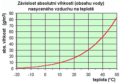
- Absolute air humidity a – the amount of water vapor in a unit volume of air. g.m-3.
- Maximum absolute humidity A – the maximum mass of water vapor that air can contain at a given temperature. If the maximum amount is exceeded, condensation occurs.
- Relative air humidity r – the ratio of the actual vapor pressure to the maximum absolute humidity A (i.e., maximum saturation), r = a/A, given as a percentage of volume.
- Saturation deficit – the difference between the maximum pressure and the actual vapor pressure.
- Specific (or mass) air humidity – the ratio of the mass of water vapor to the total mass of moist air in the same volume. A dimensionless quantity.
- Mixing ratio – the ratio of the mass of water vapor to the total mass of moist air, dimensionless.
- Dew point – the temperature at which water vapor in the air would become saturated. This can also occur during adiabatic cooling = without the addition of water vapor. When the temperature drops below the dew point, condensation occurs – dew, fog. With humidity below 100%, it is always lower than the air temperature, given in °C.
Atmospheric pressure
Air pressure is exerted equally in all directions at all points on the Earth’s surface. Air (the atmosphere) has mass, and with it, it exerts pressure on the Earth’s surface – pressure. Pressure is the force applied at a given point in the atmosphere perpendicular to any oriented surface. The average pressure at sea level and at a temperature of 15°C is 1013.27 hPa. With altitude, pressure changes – 1 hPa/8 m (according to the source8).
Klima skripta. Gisáci na UPOL: GIS GEOINFORMATIKA A ROMANTIKA [online]. Olomouc: MarijaStudio, 2007 [cit. 2017-09-03]. Dostupné z: http://www.gisaci.upol.cz/filesftp/Klima_skri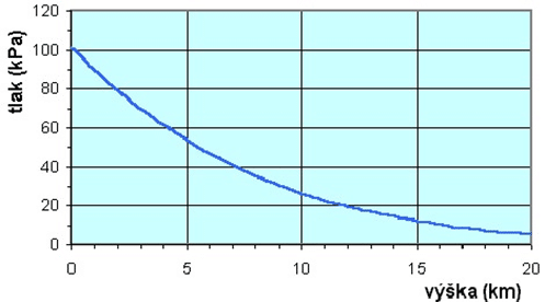
Gas state equation [17] – p × v = r × T, where p=pressure, v=specific volume, T=absolute temperature, r=gas constant and depends on the nature of the gas (287 m2s-2K-1). Air density is directly dependent on pressure and indirectly on its temperature.
Pressure field – baric field – the horizontal distribution of air pressure is a result of the variability of solar radiation falling on the Earth’s surface and determines the wind regime. The distribution of atmospheric pressure is called the baric field, areas of the same pressure are connected by isobars.
Isobaric topography maps – capture the constantly changing position of isobaric surfaces.
Absolute baric topography map – in the map, the heights of isobaric surfaces above sea level are plotted. If only higher isobaric surfaces are placed above lower ones, it is a relative baric topography map.
Horizontal distribution of pressure according to the source9
NEČAS, Tomáš. Physics in the Atmosphere or Basics of Meteorology: Modular System of Further Education for Pedagogical Workers JmK in Natural Sciences and Informatics CZ.1.07/1.3.10/02.0024. Brno: Faculty of Science, Masaryk University in Brno, 2011.
- Pressure is not the same everywhere, even when adjusted to sea level (87 kPa – 109 kPa),
- A pressure gradient forms, leading to air circulation,
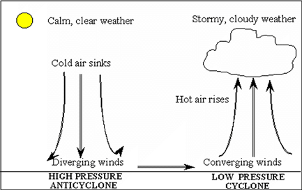
- High-pressure area (anticyclone) and low-pressure area (cyclone), as shown in the figure.
Basic pressure systems according to the source10
Climate scripts. GIS at UPOL: GIS GEOINFORMATICS AND ROMANTICS [online]. Olomouc: MarijaStudio, 2007 [cited 2017-09-03]. Available from: http://www.gisaci.upol.cz/filesftp/Klima_skripta.pdf:
The pressure field is composed of areas of high and low air pressure.
- Cyclone – TN – closed isobars, with the lowest pressure at the center.
- Anticyclone – TV – closed isobars, with the highest pressure at the center.
- Low pressure trough – V-shape, with the lowest pressure along the axis, between two TVs. High-pressure ridge – U-shape, with the highest pressure along the ridge.
- Baric saddle – an area in the atmosphere, between two TVs or TNs, a neutral point.
Temporal changes in air pressure – non-periodic nature, gradual (max. 20-30 hPa/day).
Diurnal pressure cycle – double cycle – maximum before noon and before midnight, minimum early in the morning and after noon. Amplitude fluctuates 3-4 hPa. Causes include daily temperature variations of the active surface, daily atmospheric oscillations, and tidal atmospheric movements. Max. 1083.3 hPa in Siberia, min. 870.0 hPa in the eye of a typhoon.
Annual cycle of air pressure – related to the seasonal movement of pressure systems and pressure changes in stationary pressure systems. Continental type – max. in winter, min. in summer. Oceanic – max. at the beginning of summer, min. in winter. Monsoonal – max. in winter, min. in summer.
Zonal distribution of air pressure – equatorial zone NT, subtropics VT, subpolar NT, polar VT. “The laws of zonal distribution of air pressure are crucial for the general circulation of the atmosphere.”.
Continuing the article here: Physics of the Atmosphere (2) (kint.cz)